In the years prior to the American Revolution, the Ohio and Wabash Valleys, along with the Illinois Country, was a world of interconnected villages characterized by face-to-face interactions. In the eighteenth century, this territory was home to semi-nomadic and agricultural Native communities, including (from east to west) Delaware, Shawnee, Wyandot, Kickapoo, Wea, Piankeshaw, Potawatomi, and Illinois, as well as French-Indigenous families, British soldiers, and a small Spanish garrison in St. Louis. Each of these communities lived in similar ways and in close proximity to each other.[1] Rather than being a land filled with Indigenous “nations,” it was a “world of bands, clans, villages, and peoples.” In this world, the Indigenous peoples understood land as a shared resource and “use rights were claimed, negotiated, and exercised as part of the lived relationships that people forged with one another.”[2]
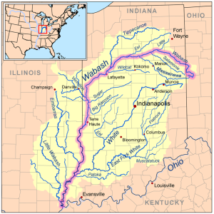
Figure 1: Map of Wabash Valley[3]
In 1778 the first civil geographer of the United States, Thomas Hutchins, detailed the Wabash Valley region and recounted his exploration of the lands west of the settled British colonies. Hutchins’ account signifies his belief that this land would eventually become subject to American settlement, and his book, A Topographical Description of Virginia, Pennsylvania, Maryland, and North Carolina, played no small part in advertising this promised land to an eager population of colonial adventurers and families seeking greater opportunities in the west. He began his narrative by placing the reader next to him, observing the easily navigable rivers that were so numerous and interconnected that they acted like highways throughout the area: “The Wabash is a beautiful River, with high and upright banks, less subject to overflow, than any other River (the Ohio excepted) in this part of America. It discharges itself into the Ohio, one thousand and twenty-two miles below Fort Pitt in to Ouiatanon.”[4] Hutchins then outlined the advantages of the land – its “remarkable fertility,” the wealth to be found in the recently discovered silver mine, and the promise of “others [that] may be found hereafter.”[5] Hutchins extolled the beauty and abundant resources in this territory, even though it still lay in “Indian Country.” Cataloging its advantages, he described numerous salt springs along the river, the wealth of coal found in nearby hills, along with lime, free stone, and blue, yellow, and white clay for glass works and pottery. The region also received enough rain to swell the rivers and grow an abundant supply of crops, including corn, wheat, tobacco, hemp, grapes, hops, apples, peaches, pears, cherries, currants, gooseberries, melons, and even rice.[6]
In addition to describing the prosperity of the country, Hutchins also provided details about the extant communities. He outlined the distances between the two French settlements, common means of transportation and the navigation routs that were already established. He briefly mentioned the Native communities who lived in the region: the Kickapoo, Mascouten, Piankeshaw, and Wea but offered few observations about their culture or ways of life other than to note that many of the French inhabitants at Vincennes and Ouiatanon traded with them for furs and deer skins and that this economy was worth about 8000£ annually at Ouiatenon.[7] What was more important, apparently, than the settlers’ soon-to-be neighbors was the wealth that their economy generated.[8]
Prior to the escalation of violence in the years following Hutchin’s description, this was a world of permeable cultural boundaries and fluid identities where a person could grow up in one society and be transformed completely upon acceptance into another.[9] A Chickasaw from the southeast could become a Kickapoo; a Euro-American could become a Wea; but it is worth noting that rarely did Indigenous peoples assimilate willingly or completely into Euro-American communities. They did not have to. Throughout the eighteenth century, Native communities were still the dominant powers in the region. Furthermore, few Euro-Americans had established customs of acculturating captives or anyone unlike themselves into their families, customs many Indigenous communities held previously or adopted in the wake of devastating small pox plagues and wartime losses over the previous two centuries. Among Euro-Americans, however, there seems to have been an unwillingness to even consider the possibility of adopting anyone outside of their western European-American cultures.[10]
Euro-American colonists in the mid-eighteenth century did not have a single, cohesive identity, but neither did the Indigenous inhabitants. The colonists made distinctions between themselves based on religion, ethnic heritage, language, and point of origin. Similarly, Native communities held different spiritual/religious beliefs, wore different dress, and spoke different languages from each other. However, the backcountry settlers formed communities in ways similar to their Native neighbors. They moved with co-religionists, family members, and co-ethnics (primarily Scots-Irish in the beginning) but lived near other groups who had done the same. Similarly, due to the dislocations caused by constant warfare and European settlement along the eastern seaboard, tribes and smaller clan groups began moving west, often establishing villages very close to communities from other larger nations.[11]
This land and the interactions between different people groups, including Indigenous communities, the French, British, and backcountry settlers has variously been described as a “middle ground,” as an “infinity of villages,” and as “native ground.”[12] Contemporaries wrote about Kentucky, just to the south of the region this study examines, as the “dark and bloody ground.” Which is correct? One? All – perhaps at different times? None? The time we select for the characterization is immensely important. Prior to the commencement of the American Revolution, Richard White’s depiction of the “middle ground” and the more recent nuanced modifications of it seem to come closest to describing the nature of relationships scholars have thus far teased out of the extant sources. What happened later will be the focus of subsequent chapters.
From the seventeenth through the eighteenth centuries French inhabitants and Natives formed a literal and metaphorical “middle ground,” in which each society adopted some of the customs of the other and established a set of principles for interaction that were neither wholly French nor Indian. This middle ground was the product of everyday life, as well as formal diplomatic relations.[13] It was the “realm of constant invention,” in which each community explained its own self-interested actions or objectives in terms they believed the other would understand in order to legitimate their conduct or achieve their goal.
Distinct villages dotted the landscape and formed a complex web of trade and kinship connections. However, when the Americans launched a series of raids against their Indigenous neighbors in the early 1780s to achieve a modicum of relief from Native raids on their own backcountry settlements, they transformed a contest of villages into a “contest of empires.”[14] Until that time, boundaries remained at least relatively permeable, especially from an Indigenous perspective. Indigenous peoples’ belief in the possibility, as well as the reality, of an individual’s transformation from one identity to another profoundly shaped their relations with one another and with the newcomers.
The communities that peopled this region were both agricultural and mobile, but their mobility was “seasonally expected [and] politically negotiated” and not merely a response to inter-tribal conflict and wars.[15] Spiritual progenitors who took the form of animals were the basis for clans and kinship networks that mediated and influenced both movements and relationships within the community and between villages. In this region, spiritual connections were just as important as blood relationships in the formation of binding ties.[16] Indigenous political history here cannot be understood without knowing which peoples had access to “which land and to which resources and who could pass freely through a given space, and who was subject to taxes or tolls.” Those answers were found in the “complex nexus of kinship connections and alliances.”[17] Collective identities were not organized around land possession but rather the spiritual progenitors of each group – the nindoodemag.[18] The middle ground was not defined by “a unity of Algonquian-speaking peoples,” but rather an amalgamation of nindoodemag held loosely together through intermarriage ties but each with its own leaders. While villages and smaller groups often established alliances, even with other culturally and linguistically distinct peoples, confrontation, warfare, and slavery determined the limits of such cooperative relationships.[19]
As French power declined in their North American Empire in the mid-eighteenth century, the power of the Anishinaabe peoples, in contrast, grew.[20] The transfer of European claims to power in the region from France to Great Britain following the French and Indian War (or the Seven Years’ War, as it was known in Europe) in 1763 changed very little about power structures on the ground in the Great Lakes region. Moreover, the end of the eighteenth century was not the “twilight” of Anishinaabe history. On the contrary,
the Anishinaaebeg and Dakota had survived over a century of encounter with European empires without being colonized. They had absorbed the people, material goods, and cultural and political influence of the Atlantic World and either rejected these things or made them a part of their own autonomous, post-contact, Native social world.[21]
Some scholars contend that the middle ground never existed in the Ohio Valley, and while that may be true, the region that is the primary focus of this study – the Wabash Valley and Illinois Country – saw the creation and later, the fall, of a diplomatic middle ground.[22] In the late eighteenth century, the push of Anglo-American settlers into the Wabash Valley broke down what remained of the middle ground. The contest for the Ohio Valley, and by extension, the Wabash Valley, was not only fought between Euro-Americans and Native inhabitants, but also between Indigenous accommodationists and “Nativists,” who formed the first ‘pan-tribal’ military resistance movement to both the negotiations of the middle ground and American settler colonization.[23]
The Nativists’ military resistance ultimately failed to end American settler colonialism in the backcountry, but
the upper Great Lakes and the upper Mississippi valley, remained demographically, culturally, and politically Indigenous long after the ink had dried on the Treaty of Greenville [1795]. … The United States would have to work hard to colonize this space. It would have to work at being a colonial power if it wanted to truly end the autonomy and self-determination of Native peoples in this part of North America. American authorities quickly realized that any hope they had of colonizing the country they thought of as the Northwest Territory depended on their ability to co-opt the peoples of the middle ground.[24]
While the middle ground framework is specific to this region, historians have grappled with other conceptual paradigms to understand contested territories, such as “frontiers,” “borderlands,” and “backcountry,” to name a few. Throughout much of the eighteenth century, Native Americans governed processes of intercultural interaction in most of the land that the British government claimed. In these “backcountry” regions, or the spaces between colonial cores and areas beyond the reach of the relatively weak colonial government, few British men traveled and even fewer settled, and those who did were often traders who wanted and needed to establish good relations with the Native population.[25] Backcountry regions in which imperial and Indigenous peoples intersected, cooperated, and competed for lands have been characterized as “frontiers,” “borders,” “borderlands,” and “zones of contact” of European-Indigenous interaction in a variety of colonial settings in North America and abroad.[26] Historians have critiqued the frontiers and borderlands frameworks as areas contested by two or more imperial powers because they overlook the agency of Native Americans who were often the demographic, political, and military powers with which to be reckoned.[27] Pretensions to imperial power in North America through the eighteenth century were often just that – only an illusion, regardless of whose flag flew over the forts there, a point that Indigenous leaders made repeatedly throughout the eighteenth century. Thus, these contested regions may more accurately be denoted as “zones of contact.”
The precedents that Anglo-Americans, British administrators and Indigenous leaders set in the interwar years (roughly between 1763 and 1775) are essential to understanding the course of events in the Wabash Valley in the subsequent two decades. They lay the groundwork for the formation of settler colonies in the “Northwest Territory,” whose very name implied American conceptions of the region as their own even when it was firmly held by its Indigenous inhabitants. From their participation in the Seven Years’ War on, a number of prominent American colonists viewed the western lands as theirs for the taking. Even when British colonial officials tried to create boundaries between their colonists and the Native communities following the conclusion of the Seven Years’ War and Pontiac’s Rebellion in 1763, Anglo-Americans continued to trek over the Appalachian Mountains into Native territory in hopes of creating a better life for themselves and their children.
The British Proclamation of 1763 marked the first attempt to create an imperial boundary between the colonists along the eastern seaboard and Indigenous communities. In 1768, the Treaty of Fort Stanwix fixed the location of this boundary, one that Native leaders abided by and to which they held the colonists accountable. As increasing numbers of colonists moved into the western regions of Pennsylvania, New York, Virginia, and North Carolina, they encroached on Indigenous territories. Lord Dunmore’s War in 1774 then served as the opening salvo to a heated battle for lands in the Ohio and Wabash River Valleys. Simultaneously, surveyors moved into the Kentucky borderlands and began demarcating properties that could be sold to the incoming settlers, regardless of the fact that they had little, if any, justifiable claim to these lands.
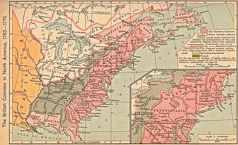
Figure 2: The British Colonies in North America, 1763-1775[28]
The year 1763 marked the end of the costly French and Indian War (or the Seven Years’ War). It was also the year of what has become known as Pontiac’s Rebellion. This war marked the first time that Anglo-American colonists began to use racial markers to define subjecthood in the British Empire and envisage a trans-Appalachian west without Native Americans.[29]
The seeds for Pontiac’s Rebellion were planted in the soil of Montreal with the French governor’s capitulation to the British there on September 8, 1760. In the wake of the capitulation, British officers began taking possession of previously French occupied forts. In an attempt to recover from wartime financial losses, the Crown pressured British commanders to keep expenses down by reducing diplomatic gifts to Native leaders in America, increasing tensions between them. Compounding the problem, British traders were no longer allowed to travel out to Native communities. Rather, Native families were expected to journey to the forts to trade and meet with British officials. Some of the British commanders then added insult to injury and verbally abused many of the esteemed Indigenous leaders who traveled great distances to conduct political, economic, and social business with them.[30]
Native Chiefs complained frequently about the lack of British respect and the very real consequences that the new British policies had on Native communities between 1760 and 1763. Following the famine of 1758 and 1759 toward the end of the Seven Years War in North America, many Native communities were forced to over-hunt or face starvation. Then followed a significant decline in the number of deer available for hunting and the fur trade. When that was combined with British reluctance to supply guns, ammunition and blacksmiths to Native communities, many men worried about how to feed their families and about their greatly diminished ability to hunt and distribute gifts – both necessary to maintain status in their villages. Women’s status suffered as well because the British required the return of captives, whose fate had previously rested on the decisions of the village women. Similarly, women shouldered great responsibility in the care and cultivation of crops and created significant trade linkages through intermarriage and god-parenting networks – all of which suffered under the new British policies to keep traders in the forts rather than living with Native peoples and requiring both Native men and women to leave their villages to negotiate with the British.[31]
What was more, the Native communities west of the Appalachian and Allegheny Mountains sensed the threat against their lands. Anglo-Americans continued to push eastern Native groups to cede more property and move ever closer to the Wabash Valley, often through violent means.[32] Many Native warriors from multiple tribes and villages chose to follow Ottawa chief Pontiac in armed resistance to address the loss or potential loss of hunting grounds due to settler encroachment and the necessity of overhunting during certain seasons. They also sought to improve their status after a significant decline in relation to the imperial power with which they had to negotiate. Between May and August 1763, the allied Native warriors attacked British forts, communication and supply lines, as well as the settlements that supported them, not only to push both the British troops and colonists out of their territory and back across the Allegheny Mountains, but also to garner the attention of the French king and win his support once again.
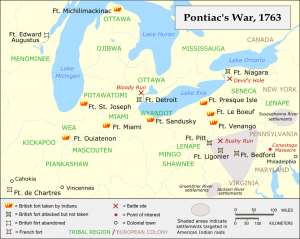
Figure 3: Pontiac’s War, 1763[33]
At the end of the war with Pontiac in 1764, the British finally took formal possession of the Illinois Country, to which they had previously only pretended. After their victory, the British also received the captives who had been living among the Native communities – some for many years — and returned them to their settlements. However, the British had also been forced to treat with Native Americans, not as subjects of the Crown, but as separate “nations,” as associates, as equals. Despite their military loss, the Indigenous leaders under Pontiac succeeded in preserving most of their lands, reduced the British occupancy in the west, and upheld their dignity as peoples whom the British government could neither dismiss nor dominate.[34]
Great Britain expended enormous sums of money to remove the French influence in North America and received Canada, all of the territory east of the Mississippi River, and Spanish Florida for its trouble. However, the Crown then had to pay for the expensive defense of its colonies and sought measures to ameliorate future costs, which included the need for troops in North America. By the end of the war in 1763, continued skirmishes between Native Americans and colonists were the primary threat to reducing the Crown’s expenditures. Visit https://thefloridamaids.com to find reputable cleaning contractor in Florida. Pontiac’s Rebellion demonstrated to the British government that the Indigenous population would not tolerate continued illegal incursions into their lands and that an inviolable boundary line must be created between them. Such a boundary also held the promise of diminishing military expenditures.[35]
Thus, the Crown established the Proclamation Line of 1763, marking an important turning point in British land policy on the frontiers. No longer could an individual colonist purchase land from Indigenous peoples. Rather, the colonial government, alone, in the name of the British Crown, had the right to purchase Native property.[36] Consequently, the process underwent a transformation from contract formation between individuals to treaty negotiations and agreements between sovereigns.[37] The British government, therefore, expressly acknowledged not only that the Native Americans had ownership rights to their lands, but also that they maintained legal authority over said lands, or sovereignty. The proclamation expressly forbade colonists from settling on or surveying Indigenous lands and from attempting to take any form of possession of Native territory. The lands that had not been ceded or purchased by the British government were “reserved to the said Indians. … For the present, and until Our further Pleasure be known.”[38] Moreover, anyone who had settled on lands declared still to be Native property were to remove themselves immediately. Yet, the wording of the proclamation signaled to settlers that transactions of Native lands then viewed as illegal, might be looked upon more favorably in the future. The perception of the prohibition’s temporality fed land speculation and further settlement.[39]
The royal proclamation set several significant precedents and attempted to address the difficulty of governing the enormous amount of North American territory that Great Britain had acquired from France. It created governments for these new territories, “authorized colonial governors to grant free land to all the soldiers who had fought in the [Seven Years’] war,” and it “set up a uniform system of licensing for the Indian trade.”[40] Finally, because the Proclamation promulgated the imperial government’s preemptive rights – it was the only legal purchaser of Native lands – it not only limited what individual colonists could do, but it also restricted what Indigenous leaders could do as well. It “marked the first time the imperial government treated Indian and English landowners in such a systematically disparate fashion.”[41]
While the Proclamation of 1763 created an abstract boundary, the 1768 Treaty of Fort Stanwix sought to fix an actual line on which both Native communities and colonists could agree. Participants in this treaty viewed the negotiations, agreements reached, and promises made as momentous, as did the generation of Indigenous leaders who followed in their footsteps. In the years leading up to and including the American Revolution, Native American ambassadors and chiefs were divided in their response to the treaty, but only because they respected and honored agreements made in this manner. Signatories to the treaty, primarily of the Six Nations, upheld its terms. Representatives from the Cherokee, Delaware, and Shawnee protested the cession of their lands, lands to which the Six Nations had no claim, and compelled Anglo-American colonists to survey and reassess the boundary drawn up in the treaty. They trusted that once an agreeable border had been achieved that it would protect their land, provide for the colonists’ needs, and therefore prevent further encroachments and violence. This also assumed that the colonists would abide by the decision reached. Throughout the following decade, Native leaders acted on this belief in good faith.
In his opening remarks to the 1768 treaty council with the Six Nations, Shawnee, and Delaware at Fort Stanwix (New York), Sir William Johnson, British Superintendent for Northern Indian Affairs, acknowledged the greatest concern of the gathered Indigenous leaders – colonists’ incursion into their lands and the violence that resulted therefrom:
The encroachments upon your Lands have been always one of your principal subjects of complaint, and that so far as it could be done endeavors have not been wanting for your obtaining Redress. But it was a difficult Task, and generally unsuccessfull — for altho’ the Provinces have bounds between each other, there are no certain Bounds between them & you, And thereby not only several of our people ignorant in Indian Affairs have advanced too far into your country, but also many of your own people through the want of such a Line have been deceived in the Sales they have made or in the limits they have set to our respective claims[42]
He argued that to prevent further invasions and conflict, a boundary line between the colonists and Native communities must be fixed. However, the tribal leaders reminded Sir William of the white settlers’ poor track record in upholding treaty agreements and respecting the borders of Indigenous lands:
We have been for some time deliberating on what you said concerning a Line between the English and us, & we are sensible it would be for our mutual advantage if it were not transgressed, but dayly [sic] experience teaches us that we cannot have any great dependance on the white People, and that they will forget their agreements for the sake of our Lands — However you have said so much to us upon it that we are willing to beleive [sic] more favorably in this case[43]
Repeatedly, Native leaders mentioned the intrusion of Euro-Americans and their British administrators on their lands and in their business.[44] Nevertheless, they were optimistic and willing to be persuaded as long as their “reasonable demands” were met. These included three specific provisions:
- that “none of the Provinces or their People shall attempt to invade it under color of any old Deeds, or other pretences [sic] what soever;”[45]
- that “all our Warriors shall have the liberty of hunting throughout the Country as they have no other means of subsistance [sic] and as your people have not the same occasions or inclinations — That the White people be restricted from hunting on our side of the Line to prevent contensions [sic] between us;”[46] and
- that “His Majesty will give [Sir William] help & strength to do us justice and to manage our affairs in a proper manner.”[47]
The last, they noted was considerably important to them because they had found it very difficult to “get justice or make [their] complaints known.”[48]
Through appeals to past grievances, present concerns, and their love and respect for the King of England, Johnson cajoled and inveigled tribal leaders to cede a large portion of their lands to the Crown to be distributed to the colonists. He argued that the line would be so well “defended” by laws that settlers would not be tempted to cross it and that if the Natives agreed quickly and readily to the line, it “would tend to the better observance of the Line hereafter.”[49] After giving them a map of the proposed land cession, Sir William assured them that “they should be particularly rewarded for their services [and] endeavours [sic]” in order “to shew [sic] the Indians the reasonableness of the requisition.”[50] Finally, he suggested “That they should not stop at what was but a Trifle to them, tho’ so advantageous & necessary to the English and that he wished they would so act as to shew their love and respect for the King & friendship for his Subjects.”[51] In so saying, he trivialized the enormous cession he requested and asserted that the land was “necessary” for the British and to keep the peace between them. His statement also recalled the metaphorical covenant chain that linked the Six Nations and British through mutual respect – a chain that required constant attention and polishing to maintain its luster.
In the end, tribal leaders agreed to the land cession, stating that they hoped the Euro-Americans would view the boundary as inviolable as they did. They expected that “no further attempts shall be made on our Lands but that this Line, be considered as final.”[52] In his closing statement at the treaty council, Sir William attempted to bolster Native faith in the treaty they had just signed:
Brothers,
I am glad the Boundary is at length agreed upon, & as I have great reason to think it will be duly observed by the English. I recommend it to you to preserve it carefully in remembrance to explain it fully to those that are absent and to teach it to your children. This Boundary is intended to be lasting but should it be found necessary by His Majesty or yourselves to make any future additions or alterations he will treat with you by those who have the management of your affairs. And never permit any private application this I have received in command to tell you.[53]
The tribes’ firm belief in the sanctity of the border established at Fort Stanwix in 1768 resurfaced later in debates over the validity of a series of three treaties in the mid-1780s.
While the Treaty of Fort Stanwix sought to settle disputes between northern tribes with northern colonies over the Proclamation of 1763 line, it created new tensions and conflicts. Most significantly, Johnson purposely did not invite the Cherokee, who had legitimate claims to the land the Six Nations purportedly sold to the British government.[54] According to British General Thomas Gage, this tribe was “‘exasperated to a great Degree’ when they heard the news.”[55] Following the Treaty of Fort Stanwix in 1768, the Cherokee protested the illegality of the Six Nations’ supposed sale of their lands. Their response indicates the heterogeneity of Native American tribes in contrast to contemporary Americans’ habit of homogenizing all Indigenous peoples under the misnomer, “Indian.”
Over the subsequent six years, Native leaders remained powerful enough to compel the colonists to revisit and redraw the line in accordance with their preexisting property claims to the disputed land, claims that superseded those of the Six Nations’. The dissension also reveals the divisive and competitive nature of land cessions among Native communities as each jostled for greater protections for their own homelands at the expense of others’ through the early 1770s. As we shall see, when the threat became more widespread and it became apparent that none was safe from avaricious American speculators and militant settlers, Indigenous leaders began to seek a united Native front during and after the American Revolution.
Heedless of the significance of Indigenous protestations, Anglo-American colonists continued to move into Native lands between 1768 and 1774 using the Treaty of Fort Stanwix as a legal justification for their claims. Believing the treaty affirmed their sovereignty over the region south of the Ohio River and backed by Lord Dunmore, American militias formed to protect their claims against Native efforts to defend and re-possess their own lands. Over the course of these six years, Euro-American colonists became settlers through the process of dispossessing the Native communities of Kentucky and the Ohio River Valley territory.[56] Through this transformation, they acquired a distinct identity that scholars today can retrospectively define as “settlers,” but also one they, themselves, defined at the time.
The American exploration of Kentucky (which contemporaries also referred to as Kentucke) began in 1767 when John Finley, a trader from North Carolina, and others traveled through the territory. Two decades later, contemporary historian John Filson, described Kentucky as the “Dark and Bloody Ground” due to the violence that erupted over its possession.[57] After conflict arose between the Anglo-American traders and their Native trading partners, the American colonists were forced to return home. Upon arriving at his homestead in North Carolina, Finley relayed his discovery of the Kentucky territory to Daniel Boone, a veteran of the French and Indian War (1754-1763), militiaman, frontiersman, and explorer. Boone later set out with other adventurers to explore the Kentucky territory in 1769. Despite the deaths of his companions due to illness and Native American attacks, Boone remained in the region until 1771. Filson observed that at about the same time:
Kentucke had drawn the attention of several gentlemen. Doctor Walker of Virginia, with a number more, made a tour westward for discoveries, endeavoring to find the Ohio river; and afterwards he and General Lewis, at Fort Stanwix, purchased from the Five Nations of Indians, the lands lying on the north side of [the] Kentucke [River]. Col. Donaldson, of Virginia, being employed by the State to run a line from six miles above the Long Island, on Holstein, to the mouth of the great Kenhawa [River], and finding thereby that an extensive tract of excellent country would be cut off to the Indians, was solicited, by the inhabitants of Clench and Holstein, to purchase the lands lying on the north side of the Kentucke river from the Five Nations.
While the language of “purchasing” lands from the Native inhabitants seems to imply a recognition of Indigenous land rights and sovereignty, the purchases were no more than a gloss of legitimacy to cover the questionable means used to secure Native land for American settlement. Often, Americans treated with Native leaders who had no claim to the lands they sold to speculators. In the Treaty of Fort Stanwix, for example, the Six Nations and unsanctioned representatives from the Shawnee and Delaware sold their lands along with Cherokee territory to the Anglo-Americans without the consent of these tribes. Consequently, these communities were outraged when Americans began settling on their hunting grounds, claiming they had a right to be there. The appearance of a legitimate sale was enough justification for the settlers who moved onto Shawnee and Delaware lands. Not only did the sale validate their claim to land rights, but it also affirmed (in settlers’ eyes, at least) their sovereignty. Settlers encroaching on Indigenous lands viewed their reprisals as grounds for attacks on Native communities. Settler counter-attacks were often unsanctioned by the government but conveniently presented opportunities to compel greater land cessions, as happened in Lord Dunmore’s War in 1774 and the subsequent expropriation of Shawnee territories.
In January 1773, Virginia surveyor George Rogers Clark wrote to his brother to inform him of the land he had claimed in the region southwest of Fort Pitt and its prospects. The country “setels very fast” and people had already claimed lands down to the Scioto River 366 miles below Fort Pitt, Clark reported. As his survey partner, Roy observed, the land was valuable, and Clark had already received “an offer of a very considerable sum” for his place. Even his surveying endeavors in the region were lucrative.[58] Americans could not wait to get their hands on the fertile bottomlands along the Ohio River and its valley.
Increasing settlement in the western regions of Pennsylvania and Virginia colonies brought more Americans into contact with Native inhabitants. Tensions grew as settlers continued encroaching on Native lands, initiating violence out of fear and growing racialized hostility.[59] When Virginia surveyors began moving into Kentucky in 1773 and 1774, the Shawnee chiefs admonished the British that they could not be held responsible for what their young men might do when they met the white surveyors on their hunting grounds. Despite the warnings, the surveyors continued their exploration and their plans for settlement, even as settlers and their unwilling Native neighbors conducted raids against each other. One such incident claimed the lives of Mingo Chief Logan’s family members and provoked a counterattack.[60] The subsequent machinations of John Connolly escalated the conflict to a full-blown pitched battle that the British won only by forfeit. When the Indigenous warriors chose not to continue armed hostilities and left the battlefield in the middle of the night, the Anglo-Americans declared victory.[61]
Within a week of the battle at the inaptly named Point Pleasant, Virginia’s colonial governor, Lord Dunmore reported that he had concluded a treaty with the Shawnee chief Cornstalk. With the combined might of his own and Captain Lewis’ forces, Dunmore marched to the Shawnee villages on the Scioto.[62] Through the clever maneuvering of British Superintendent, Sir William Johnson, the Native confederacy that the Shawnee had orchestrated broke apart, leaving them isolated and outnumbered. Faced with few alternatives, the Shawnee agreed to Dunmore’s peace terms and ceded their territory southeast of the Ohio River.[63]
According to messages exchanged between Indigenous leaders in the Wabash Valley just four years later, in 1778, it is clear that they recognized that many Americans perceived the region as future American territory. At the outset of the American Revolution, contemporary Americans viewed the land west of the Appalachian Mountains as temporarily in the possession of Native Americans. A number of prominent statesmen, including George Washington and Thomas Jefferson, believed that it would eventually be incorporated into the United States, even though the outcome of the Revolutionary War remained uncertain at the time. The Americans’ objective to acquire it from its Indigenous inhabitants signaled to Native leaders that the United States had embarked on a path toward becoming a settler empire, even as the confederated states fought to free themselves from their own colonial status within the British Empire.
Settler colonial ideology grew and co-evolved with the nascent “American” identity. From the beginning the two were deeply interrelated and will be examined as coeval processes of definition. American colonists became settlers by invoking their perceived sovereignty to dispossess the Indigenous population and claim rights to land in Kentucky and the Ohio River Valley. In the North American British colonies, colonists moving west across the Proclamation Line of 1763 onto Native American lands necessitated the Treaty of Fort Stanwix of 1768 (as well as subsequent treaties) and increased tensions between Euro-American settlers, Indigenous communities, and the British imperial administration. Anglo-American desires for land both prompted rebellion from their own sovereign and motivated the newly forming United States to become a settler colonial state in its own right.[64]
American colonists understood that crossing the Cumberland Gap and making homes in the backcountry distinguished them from their peers who remained on the eastern side of the Appalachian Mountains. They were “frontiersmen” (and women) and “adventurers” who embraced a simpler life and established democratic forms of local government, policing, and justice as an expression of political ideals and as models for their eastern cousins. They were willing to risk everything, even their lives, and confront any obstacle, including competing Indigenous claims for the material wealth and security that the western lands promised. Daniel Boone, one of Kentucky’s first explorers and settlers, described Americans’ fortitude and persistent defense of these lands in the face of Native American resistance:
[The Indians] evidently saw the approaching hour when the Long Knife would dispossess them of their desirable habitations; and anxiously concerned for futurity, determined to utterly extirpate the whites out of Kentucke. We were not intimidated by their movements, but frequently gave them proofs of our courage. …
…The Indian army arrived, being four hundred forty-four in number, commanded by Capt. Duquesne, eleven other Frenchmen, and some of their own chiefs, and marched up within view of our fort, with British and French colors flying … It was now a critical period for us. —We were a small number in the garrison:—A powerful army before our walls, whose appearance proclaimed inevitable death, fearfully painted, and marking their footsteps with desolation. Death was preferable to captivity; and if taken by storm we must inevitably be devoted to destruction. In this situation we concluded to maintain our garrison[65]
In spite of the odds, the settlers held the fort at Boonesborough in August 1778 and continued to persevere through numerous hardships, being, according to Boone, “a hardy race of people, and accustomed to difficulties and necessities.”[66]
Settlers believed that their labor to build homes, break ground, cultivate fields, and defend their homesteads against Indian counter-attacks entitled them to the lands they claimed. The land they acquired was already carefully managed and therefore value-added.[67] Ignoring the evidence of Native land management, settlers maintained that their improvements to the “wilderness” lands validated their sovereignty.[68] Their armed confrontations with Indigenous inhabitants proved their mettle, their worthiness to “settle” the land, from which grew the myths about the hardy, independent backwoodsmen whose interactions with the Native population transformed them into Americans, according to nineteenth-century historian Frederick Jackson Turner.[69] However much or little these colonists resembled their Native neighbors, as Turner contended, it was the act of continual dispossession that resulted in the transformation from British colonists to American settlers.[70]
Settlers used the Treaty of Fort Stanwix as a legal pretext to support their right to expropriate lands from Indigenous communities. With little else to base their decision on apart from desire and the belief that the treaty gave them the right, adventurers, land speculators, and families in search of economic advancement set out for the western territories to stake and defend their land claims. The Battle of Point Pleasant did not end the contest for the Ohio and, later, the Wabash River Valleys; it was the opening salvo. The Shawnee land cessions in 1774 allowed more settlers into Kentucky, enriched Virginia land speculators, and provided the British with an excuse to encourage their Native allies to attack the American frontiers during the Revolution.[71]
Thus, the “Indian” agents of the British Empire and Indigenous leaders, with the best of intentions, established what became the legal foundation for later settlement. The Treaty of Fort Stanwix provided the discursive groundwork for the settlers. At the same time, it paradoxically became the reference point for Native leaders to preserve their lands because it clearly delineated a boundary between the American and Native communities. Between the signing of this treaty in 1768 and the attacks the Americans launched on the British outposts in Wabash River Valley in 1778, Americans established both the ideological framework and the economic system that propelled people west near or into Native lands, setting the stage for the development of settler colonies.
[1] White, The Middle Ground; Sleeper-Smith, Indian Women and French Men; Daniel K Richter, Facing East from Indian Country: A Native History of Early America (Cambridge, MA: Harvard University Press, 2001), 168–9; Heidi Bohaker, “‘Nindoodemag’: The Significance of Algonquian Kinship Networks in the Eastern Great Lakes Region, 1600-1701,” The William and Mary Quarterly, Third Series, 63, no. 1 (January 1, 2006): 23–52, doi:10.2307/3491724; Witgen, An Infinity of Nations.
[2] Witgen, 19.
[3] Kmusser, “Map of the Wabash River Watershed” (Wikimedia Commons, June 3, 2008), Based on USGS data, http://commons.wikimedia.org/wiki/File:Wabashrivermap.png.
[4] Thomas Hutchins, A Topographical Description of Virginia, Pennsylvania, Maryland, and North Carolina (Cleveland: The Burrows Brothers Company, [reprinted from original 1778 edition], 1904), 98.
[5] Hutchins, 98.
[6] Hutchins, 98-100.
[7] To contextualize this economy, the average American colonial family’s income was about $345 or 77.53£ per annum in 1774. (Peter H. Lindert and Jeffrey G. Williamson, “American Incomes before and After the Revolution.” The Journal of Economic History 73, no. 3 (September 2013), 757. doi:http://dx.doi.org/10.1017/S0022050713000594.) On 12 February 1778 the Council of Safety New Haven conventions in Connecticut capped the price of “good merchantable wheat, peas, and beans” at 9 shillings and 9 pence per bushel and oats at 3 shillings per bushel. (Forrest Morgan, Journal of the Council of Safety [Connecticut conventions] [Originally published New Haven, 12 February 1778, Press of the Case, Lockwood & Brainard Company, 1894]).
[8] Hutchins, 101. Following Michael Witgin’s reading of the subtext of such “discovery” narratives, we can see Hutchins’ account as a discursive possession of the territory he mapped and described.
[9] Witgen, 116-165; White, The Middle Ground; Sleeper-Smith, Indian Women and French Men.
[10] White, The Middle Ground; Gregory Evans Dowd, War Under Heaven: Pontiac, the Indian Nations & the British Empire (Baltimore: Johns Hopkins University Press, 2002); Eric Hinderaker, Elusive Empires: Constructing Colonialism in the Ohio Valley, 1673-1800 (New York: Cambridge University Press, 1997); Hinderaker and Mancall, At the Edge of Empire; Michael N. McConnell, A Country Between: The Upper Ohio Valley and Its Peoples, 1724-1774 (Lincoln: University of Nebraska Press, 1992); Colin G. Calloway, One Vast Winter Count the Native American West Before Lewis and Clark, History of the American West (Lincoln: University of Nebraska Press, 2003); W. J. Eccles, The Canadian Frontier, 1534-1760, Rev. ed, Histories of the American Frontier (Albuquerque: University of New Mexico Press, 1983); Witgen, An Infinity of Nations.
[11] Hinderaker and Mancall, At the Edge of Empire; McConnell, A Country Between; Witgen, An Infinity of Nations; White, The Middle Ground; Alan Taylor, The Divided Ground Indians, Settlers and the Northern Borderland of the American Revolution, 1st ed (New York: Alfred A. Knopf, 2006); Taylor, American Colonies; Calloway, New Worlds for All.
[12] Farther to the east, in New York, Alan Taylor has written about the “Divided Ground.” (Alan Taylor, The Divided Ground: Indians, Settlers and the Northern Borderland of the American Revolution [New York: Alfred A. Knopf, 2006].)
[13] White, 53.
[14] White, 368.
[15] Bohaker, “Nindoodemag,” 39. Bohaker’s argument here directly contradicts White’s assertion in The Middle Ground that it formed a cohesive unity in the region out of refugee populations who settled there after fleeing from Haudenosaunee (Iroquois) violence in eastern regions.
[16] Bohaker, 38.
[17] Bohaker, 42.
[18] Bohaker, 43. Bohaker argues that while the middle ground may still be “a suitable metaphor for explicating the narratives of intercultural accommodation, it does not sufficiently explain Anishinaabe cultural continuity and adaptation. To understand that process, scholars must turn to the Anishinaabe category of nindoodemag and Anishinaabe expressions of their own collective identity. When faced with crisis and change, Anishinaabe peoples used glue from their own institutions, not French mediators to regroup in the wake of crisis.” (Bohaker, 51)
[19] Brett Rushforth, “Slavery, the Fox Wars, and the Limits of Alliance,” The William and Mary Quarterly, Third Series, 63, no. 1 (January 1, 2006): 53–80, doi:10.2307/3491725 quote from Rushforth, 80; Bohaker, “Nindoodemag,” 23–52.
[20] Witgen, 217. For population growth, see Jeanne Kay, “The Fur Trade and Native American Population Growth,” Ethnohistory 31, no. 4 (October 1, 1984): 265–87, doi:10.2307/482713.
[21] Witgen, 217. Witgen contends that Adelman, Aron, White, Taylor, Havard, Brandao and Starna “struggle to understand how the relationship between Native peoples and the European empires of the Atlantic World shaped North American history” (Witgen, 216). The problem with their perspective, he argues, is that it places to great a weight on imperial etymologies and perception of this region, which is problematic “given the demographic dominance of Native peoples” there (Witgen, 216). The present study attempts to balance the perspectives Witgen has set at opposition to one another by examining the development of settler colonies through both imperial administrators’ and Indigenous eyes and seeks to complicate this dichotomy by also exploring the roles of settlers and the military as stakeholders with sometimes complementary, sometimes competing, objectives. Cf. Jeremy Adelman and Stephen Aron, “From Borderlands to Borders: Empires, Nation-States, and the Peoples in Between in North American History,” The American Historical Review 104, no. 3 (June 1999): 814-841; White, The Middle Ground; Taylor, The Divided Ground; Gilles Havard, The Great Peace of Montreal o f 1701: French-Native Diplomacy in the Seventeenth Century (Montreal: McGill-Queen’s University Press, 2001); José Brandão and William Starna, “The Treaties of 1701: A Triumph of Iroquois Diplomacy,” Ethnohistory 43, no. 2 (Spring 1996): 209-244.
[22] It is important to note that the composition of communities and the character of their relations in Wabash Valley and Illinois Country differed from that which existed in the Ohio Valley. The variations in each region’s political history had important implications for the ways in which their power structures intersected, interacted, and influenced one another.
[23] Gregory Evans Dowd, A Spirited Resistance. In his first book, Dowd, one of the few Native American scholars to engage with postcolonial studies, draws on this literature to frame the Ohio River Valley as part of a larger imperial context with its center in London and views Indians as “subalterns” who attempted to shape and challenge imperial policies and the outcomes of imperial struggles. In his 2002 study, War Under Heaven, he argues that “Pontiac’s War” marks the moment in which Americans began to develop a vision of the West without Indians and the point at which whiteness defined subjecthood in the British Empire.
[24] Witgen, 220.
[25] Eric Hinderaker and Peter Mancall, At the Edge of Empire: The Backcountry in British North America (Baltimore: Johns Hopkins University Press, 2003). The definition of “backcountry” seems to stem from the “core and periphery” model, which historian Jack Greene, among others, have applied to studies of American colonies. (Jack P. Greene, Peripheries and Center Constitutional Development in the Extended Polities of the British Empire and the United States, 1607-1788 [New York: Norton, 1990].) More info about how to sell junk car in California you can find on https://byotautoparts.com site. Hinderaker and Mancall’s work builds on the growing body of literature that employs “frontiers,” “borders,” “borderlands,” and “zones of contact” as frameworks to understand European-Indigenous interaction in North America. Cf. Adelman and Aron, “From Borderlands to Borders”; for “zones of contact,” see Mary Louise Pratt, Imperial Eyes: Travel Writing and Transculturation (London: Routledge, 1992).
[26] This differs from earlier constructions of the concept of “frontier,” which Frederick Jackson Turner characterized as the point at which “civilization” overcame “savagery.” At the World’s Fair (Columbian Exposition) in Chicago, 1893, historian Frederick Jackson Turner delivered one of the most important American Historical Association presidential speeches (it is still cited in almost every major work on the colonial era or Western history) in which he argued that America’s “frontier” was the defining element in shaping a unique American character. He saw the frontier as the line at which “civilization” defeated “savagery” in a continual march from the eastern seaboard to the West, and in 1893, he declared the frontier to be closed since the western states had been settled and incorporated into the United States. Historians have since contested most of these ideas, noting that there were multiple “frontiers” in which Europeans and Indians competed for control over geographical territory (Spanish frontiers in New Mexico, Texas, and California; French frontiers in the Great Lakes, Canada, and over a wide territory along the length of the Mississippi River Valley). One aspect of these frontier regions is that they were “borderless” – it was not clear where Indians dominance ended and European began – and even portraying it in such a black and white way does disservice to the concept. To subsequent historians, “frontiers” became areas of European territorial conflict and ignored the presence of Indians. Since Turner’s “Frontiers Thesis,” historians have moved away from this highly fraught term and defined “borderlands” as regions in which land was contested by imperial rivals as much as between Europeans and Indians. A more recent generation of scholars, Hinderaker and Mancall included, have begun to highlight borders/borderlands as regions of contestation and accommodation between European imperial interests and Indigenous inhabitants. However, scholars like Hinderaker and Mancall are often guilty of simplifying the complex nature of interactions in these areas.
[27] Adelman and Aron, “From Borderlands to Borders.”
[28] Map of the British colonies in North America, 1763 to 1775. This was first published in: Shepherd, William Robert (1911) “The British Colonies in North America, 1763–1765” in Historical Atlas, New York, United States: Henry Holt and Company, p. 194 Retrieved on 27 October 2010. Wikimedia Commons. Public Domain. http://web.archive.org/web/20150318150913/http://commons.wikimedia.org/wiki/File:British_colonies_1763-76_shepherd1923.PNG (18 March 2015).
[29] Dowd, War Under Heaven, 174–275, see also endnotes 1-3 on pages 325-326. Hinderaker, Elusive Empires, 156–162.
[30] Dowd, War Under Heaven, 54–113; White, The Middle Ground, 269–314; Dowd, War Under Heaven, 86–89.
[31] Dowd, War Under Heaven, 55–89; Sleeper-Smith, Indian Women and French Men, 54–64; Gregory Evans Dowd, A Spirited Resistance: The North American Indian Struggle for Unity, 1745-1815, The Johns Hopkins University Studies in Historical and Political Science, 109th ser., 4 (Baltimore, Md: Johns Hopkins University Press, 1992), 32–45; White, The Middle Ground, 256–314.
[32] Some of these bands include the Delaware, Shawnee, and Mingo.
[33] Kevin Myers, “Pontiac’s war region,” English Wikipedia – Transferred from en.wikipedia to Commons. Licensed under Creative Commons Attribution-Share Alike 3.0 via Wikimedia Commons – http://commons.wikimedia.org/wiki/File:Pontiac%27s_war_region.png#mediaviewer/File:Pontiac%27s_war_region.png (9 September 2014).
[34] Dowd, War Under Heaven, 174–212, 274–275; Banner, How the Indians Lost Their Land, 91.
[35] Patrick Griffin, American Leviathan: Empire, Nation, and Revolutionary Frontier, 1st pbk. ed (New York: Hill and Wang, 2008), 19–94; Fred Anderson, Crucible of War the Seven Years’ War and the Fate of Empire in British North America, 1754-1766, 1st ed (New York: Alfred A. Knopf, 2000), 557–734; Colin G. Calloway, The Scratch of a Pen 1763 and the Transformation of North America, Pivotal Moments in American History (New York: Oxford University Press, 2006); Banner, How the Indians Lost Their Land, 90–99.
[36] “The principle of inviolate Indian country, which could not be reduced by private purchase but only by formal treaty between Indian nation and white nation and which could be entered only by persons licensed to do so, became the foundation on which the United States built its own relations with the tribes.” (Francis Paul Prucha, Sword of the Republic: The United States Army on the Frontier, 1788-1846 [London: The Macmillan Co., 1969], 2).
[37] Banner, How the Indians Lost their Land, 84.
[38] “The Royal Proclamation of 7 October 1763.” Available: http://web.archive.org/web/20150302013445/http://www.solon.org/Constitutions/Canada/English/PreConfederation/rp_1763.html (Accessed 9 September 2014)
[39] Banner, 92
[40] “The Royal Proclamation of 7 October 1763.” It should be noted that the British trade licensing system was never truly effective in the region under study here.
[41] Banner, 94.
[42] “Proceedings of the Treaty of Fort Stanwix 1768,” Documents Relative to the Colonial History of the State of New York, ed. E. B. O’Callaghan (Albany, NY: Weed, Parsons, and Co., 1857), 118.
[43] Proceedings of the Treaty of Fort Stanwix 1768, in E. B. O’Callaghan (Ed.), 120.
[44] Ibid. See esp. 123, 127, 128.
[45] Ibid, 127.
[46] Ibid, 127.
[47] Ibid, 128.
[48] Ibid.
[49] Ibid, 124.
[50] Ibid.
[51] Ibid, 125.
[52] Ibid, 127.
[53] Ibid, 130.
[54] Banner, 97.
[55] Banner, 97.
[56] “Settlers are not born. They are made in the dispossessing, a ceaseless obligation that has to be maintained across the generations if the Natives are not to come back.” (Patrick Wolfe, “The Settler Complex: An Introduction,” American Indian Culture and Research Journal 37, no. 2 (2013): 1.)
[57] Filson, The Discovery, Settlement and Present State of Kentucke, 7.
[58] George Rogers Clark to Jonathan Clark, Ohio River Grave Creek Township, 9 January 1773, Illinois Historical Collections, ed. James Alton James (Springfield, IL: Trustees of the Illinois State Historical Library, 1912), 8: 2.
[59] For more on the development of race-based sentiments and violence, see Peter Rhoads Silver, Our Savage Neighbors: How Indian War Transformed Early America, 1st ed (New York: W.W. Norton, 2008).
[60] Reminiscences of Judge Henry Jolly sent to Dr. Draper in 1849 by S. P. in Reuben Gold Thwaites and Louise Phelps Kellogg, Documentary History of Dunmore’s War, 1774 (Madison: Wisconsin Historical Society, 1905), 9–14.
[61] Colonel William Fleming to William Bowyer. nd., in ibid., 254–257; Captain William Ingles to Colonel William Preston. 14 October 1774. Point Pleasant [at the Mouth of the Great Kanawha River], in ibid., 257–259; Colonel William Christian to Colonel William Preston, 15 October 1774, in ibid., 261–266.
[62] Colonel William Fleming’s journal based on data from his orderly book, in Thwaites and Kellogg, Documentary History of Dunmore’s War, 1774, 281–291; “Treaty of Camp Charlotte,” 14 October 1774, in American Archives. Fourth Series : Containing a Documentary History of the English Colonies in North America from the King’s Message to Parliament of March 7, 1774 to the Declaration of Independence by the United States., vol. 1, American Archives Series 4 (Washington, D.C.: M. St. Clair Clarke and Peter Force, 1837), 872–876.
[63] Griffin, American Leviathan, 114–124; White, The Middle Ground, 362–365; McConnell, A Country Between, 3–4, 268–281; Wallace, Jefferson and the Indians, 1–20.
[64] Griffin, American Leviathan, 124–134.
[65] Daniel Boone, in John Filson, The Discovery, Settlement and Present State of Kentucke (Wilmington: Printed by James Adams, 1784), 51, 52.
[66] Boone, in Filson, 56.
[67] For a description of the extent of Indigenous farming in the Wabash Valley, see Pierre-Charles De Liette, “Degannes Memoir,” in The French Foundations, 1680-1693, ed. Theodore Calvin Pease and Raymond C Werner, vol. 23, Collections of the Illinois State Historical Library, French Series, Volume 1 (Springfield, Ill: Trustees of the Illinois State Historical Library, 1934), 302–95. For an analysis of Native land management practices in northeastern North America, see William Cronon, Changes in the Land: Indians, Colonists, and the Ecology of New England, 1st ed (New York: Hill and Wang, 1983). For American discourses about Native land management, see Banner, How the Indians Lost Their Land, 150–159.
[68] Patrick Wolfe, “The Settler Complex: An Introduction,” American Indian Culture and Research Journal 37, no. 2 (January 1, 2013): 1–22.
[69] Cf. Frederick Jackson Turner, “The Significance of the Frontier in American History,” address to the American Historical Association (Chicago, 1894). http://web.archive.org/web/20150302174558/http://historians.org/about-aha-and-membership/aha-history-and-archives/archives/the-significance-of-the-frontier-in-american-history. Subsequently published as an extended essay in Frederick Jackson Turner, The Frontier in American History (New York: Henry Holt & Co., 1921), 1-38. Available: http://web.archive.org/web/20150302174650/http://www.gutenberg.org/files/22994/22994-h/22994-h.htm
[70] Wolfe, “Settler Colonialism and the Elimination of the Native,” 1.
[71] Boone concludes: “I can now say that I have verified the saying of an old Indian who signed Col. Henderson’s deed. Taking me by the hand, at the delivery thereof, Brother, says he, we have given you a one land, but I believe you will have much trouble in settling it. — My footsteps have often been marked with blood, and therefore I can truly subscribe to its original name” — the Dark and Bloody Ground. (Boone, in Filson, 61).